ZIP Code Data Now Available in the SparkMap Assessment
The data you need, all in one place, and now at the ZIP code level! For the first time ever, SparkMap is offering ZIP code breakouts for nearly 100 of our indicators. Get data for every ZIP code in your assessment area – view alongside our dynamic data visualizations or download for offline use.
Wow – tell me more!
After many customer requests, we’ve made our ZIP code-level data available in the SparkMap Community Needs Assessment. You can now see or download data for every ZIP code in your assessment area, using the County List, Draw My Area, or Pick from Map tools.
What data are available at this level?
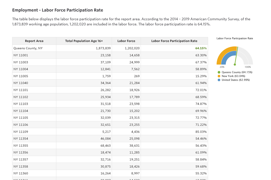
Any of our indicators that are available at the ZCTA or census tract levels are included in the ZIP code report. This includes indicators on demographic data, commuter patterns, income, poverty, housing, food access, and more. To see our indicator list and what geographies are available, visit the SparkMap Report Data List page and click on ‘Source Geography’ to sort (Figure 1).
What is the difference between ZIP code and ZCTA? Which does SparkMap use?
As a geographic data community, we often use the term “ZIP code” when referring to either a ZIP code or a ZCTA boundary.
Technically, a ZIP code is a non-spatial designation by the United States Postal Service, created as a way to group mailing addresses. ZIP codes are not defined geographic boundaries and update frequently, based on factors such as population shifts and mail volume changes.
Because of the popularity of understanding neighborhoods and regions using the familiar language of ZIP codes, the Census Bureau created ZIP Code Tabulation Areas (ZCTAs) in the year 2000 as a geographic area corresponding to a ZIP Code. ZCTAs only change every 10 years, and are a standard in neighborhood-level geography.
SparkMap uses ZCTA boundaries, where appropriate, to align with the Census Bureau’s geographic standard.
For more information about the difference between ZIP codes and ZCTAs, check out guidance on ZIP Code Tabulation Areas (ZCTAs) from the Census Bureau and All about ZIP Codes from the Missouri Census Data Center.
How can I get in on this?
This new feature is available to Premium Annual subscribers. Learn more about our Subscriptions.
Already a Premium Annual subscriber? Learn how to access the ZIP Code data in our support materials.