Building a Multi-Layer Map: Part One
Maps have the power to tell stories, highlight opportunities, and uncover issues about a place. Making an easy-to-understand, helpful, and impactful map can be difficult, though. You often need more than one layer to show relationships between social determinants and specific populations or to show change over time in a place. This series, “Building a Multi-Layer Map,” will help you use the SparkMap Map Room to build multi-layer maps which in turn can help you tell a more compelling and colorful story about a community.
Part One will focus on the basics – what to consider as you select data layers and how to add more than one layer to a map.
Considerations for Selecting Map Layers
Adding and viewing more than one layer on a map can be challenging. After all, there are a few complex considerations to take into account:
- Are the layers available at the same geographies?
- Are the data from the same year/time span?
- How many are points? Polygons? Lines?
- Does the map tell a clear story?
- Are we comparing apples to apples? Or apples to oranges?
While few in number, these considerations are foundational to building a good multi-layer map. They are also questions that need to be explored and practiced in order to gain confidence in answering them. In the next section, we will select and explore data layers as we keep these considerations in mind. We will review our layer selections in context of these questions and highlight some best practices for you to keep in mind as you make your own maps.
How to Add More Than One Layer to a Map
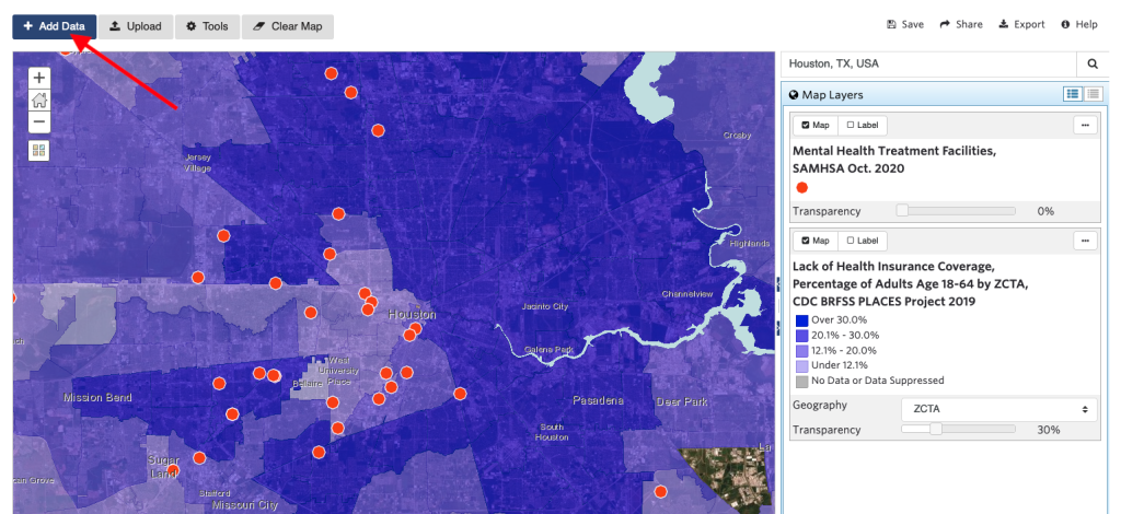
1. Let’s start at the beginning – adding two layers to a map. For this example, we will focus on data related to mental health access. Specifically, we are using:
- Lack of Health Insurance Coverage, CDC BRFSS Places Project, 2019
- Mental Health Treatment Facilities, SAMHSA, 2020
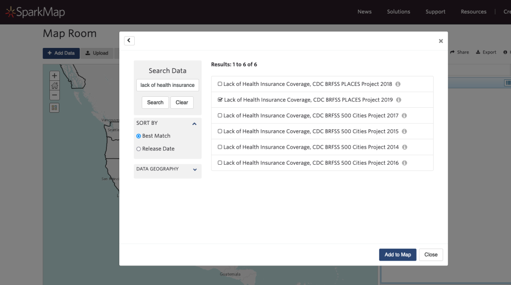
Add data to a map by selecting the checkbox next to the layer you want to view in the SparkMap Map Room. The search window will open automatically and you can type in the name of the layer or a keyword to get started. If you don’t know the specific name of the layer you’re looking for, we suggest using a general key word or phrase, like “health insurance,” to maximize your layer results. Once you’ve found the layer you want to map, click the “Add to Map” button at the bottom of the search window.
Add another layer to your map by clicking the “Add Data” button in the upper left corner of the Map Room. Type in the name of the layer or a keyword to find more data. Once you’ve found the layer you want to map, click the “Add to Map” button at the bottom of the search window.
Let’s stop to note that these layers are available at different geographies – the mental health care facility layer is at a location or point-level geography (e.g. – restaurant location pins on a Google map), while the lack of health insurance coverage layer is presented at a ZIP code geography (e.g. – what you put on your return address). Other geographies you may notice while using the Map Room include:
- National
- State
- County
- Census tract
- City or town
- Census block
- Congressional district
- School district
2. Next, zoom to your location of interest. In this example, we’ve selected the Houston, Texas metro area.
3. Now, let’s examine what the data are saying. First, the lack of health insurance layer tells us the percentage of people age 18-64 that do not have adequate health insurance coverage within a given ZIP code. The data on the map show that adults in the eastern ZIP codes of Houston are less likely to have adequate health insurance than those in the western portion.
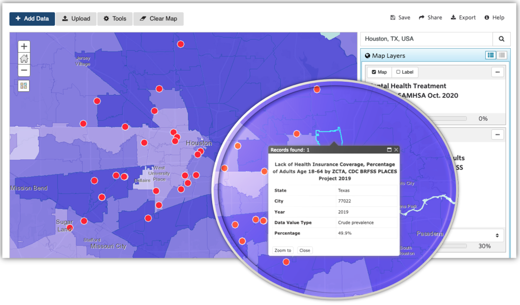
Click a ZIP code on the map and explore the pop up for more specific data. The ZIP code selected in this example shows that almost 50% of the adults aged 18-64 who live there lack health insurance.
The mental health facilities layer represents what we call a point layer, or locations. Think of point data as the red pins on a Google map – they define a specific location – either by postal address or by latitude and longitude coordinates. In this example, the red dots represent locations of mental health facilities across Houston. Notice that most mental health facilities are located predominantly in Houston’s western ZIP codes and are largely absent from the areas in the east where the rates of uninsured and underinsured are higher. This uneven distribution of facilities can create access issues and barriers to care.
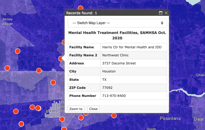
Click on the facility “dots” to view additional information.
4. Finally, let’s circle back to the considerations we started out with. These questions will help us check in on the validity and trajectory of our multi-layer map and story:
- Are the layers available at the same geographies?
No, our layers are not at the same geography. One layer is point-level and the other is at ZIP code-level, but they can be viewed simultaneously. No concerns about mismatching or overlapping geographies at this time.
- Are the data from the same year/time span?
No, but they are within one year of each other. With secondary data, it’s often impossible to line up collection and release dates across data sets and sources. Here, the lack of health insurance layer shows data for 2019 while the mental health facilities layer shows data from 2020. Best practice would be to consider recency and how far apart the data were collected/if there are overlapping time frames. Given the recency of both layers and the difference of only one year, we feel it’s safe to view these together in our map.
- How many are points? Polygons? Lines?
One point layer (mental health facilities) and one polygon layer (lack of health insurance). As we continue on in our multi-layer map series, we will define polygons, add additional polygon layers, and add lines. We will also learn how to best manage overlapping polygons and visualizations on the map.
- Does the map tell a clear story?
The map is beginning to tell a story about access (or lack of access) to mental health care in the Houston, TX area. The layers are clear, but the map could use additional refinement before it is ready for publishing.
- Are we comparing apples to apples? Or apples to oranges?
Apples to apples. We know that health insurance status is one of the biggest barriers to mental health treatment among adults.1 And location matters when it comes to healthcare access.2
Practice Makes Perfect
The best way to get to know multi-layer maps is to make and explore as many as you can. We put together some data below to help you practice layering. Search for and add the following layers to a map. Answer the questions above on your own as you’re building the map.
- Population with Limited Food Access, No Vehicle, USDA, 2019 and Food Desert Census Tracts, Change, FARA, 2015-2019
- Median Household Income by Tract, ACS, 2015-2019 and Housing Unit Value, Median by Tract, ACS, 2015-2019
- Youth Not Enrolled in School and Not Employed, Percent by Tract, ACS 2015-2019 and Majority Minority Schools NCES, 2019-2020
- Life Expectancy at Birth, Years by ZCTA, CDC, 2010-2015 and Population Below 50% Poverty Level (Adult Age 18-64), ACS, 2015-2019
Tune in next month for Part Two, where we will add more layers to our example map, work with labels and layer positioning, and continue to round out our story around mental health care access in the Houston, Texas area.
1 https://ps.psychiatryonline.org/doi/epdf/10.1176/appi.ps.201400248
2 https://www.ncbi.nlm.nih.gov/pmc/articles/PMC8214217/