
ACS 2020 Release – What You Need to Know
American Community Survey (ACS) 2016-2020 data are coming soon. Read on to learn what you need to know and do before we roll out the changes!
★ Useful for all SparkMap users
Follow along to learn the answers to the following:
- When is ACS data coming to SparkMap?
- What will be added or changed?
- How can I prepare for the changes?
When is ACS data coming to SparkMap?
Short answer: end of April through May
Map Room: We will be adding new American Community Survey 2016-2020 map layers starting this month, April 2022, and completing the updates in mid-May 2022.
Assessment: We anticipate that new ACS-based indicators will be updated in the Assessment by mid-May 2022.
What will be added or changed?
Short Answer: The ACS update will add, remove, and update data in the Map Room and Assessment. Additionally, some census tracts will update – new tracts will be added and old tracts will be removed. Small area estimates will also update.
Map Room: We will be adding new map layers for the American Community Survey 2016-2020 5-year estimates. Old ACS 2015-2019 map layers will still be available after the update.
Assessment: We will be updating about 80 indicators in the Assessment whose source is ACS 2015-2019 to the ACS 2016-2020 estimates. This update will override existing ACS 2015-2019 indicators. To help you transition, we’re also planning to launch an additional “2015-2019 ACS data” assessment at the time of the new data release.
Geographies: Census tracts and cities and towns may change.
Census tracts: Although designed to be relatively permanent, with every 10 year Census, census tracts may merge or split, depending on population. Tracts with more than 8,000 people are split; tracts with less than 1,200 people are merged. New numeric codes are given to these tracts rendering previous codes unusable.
Cities/towns: There may be significant changes to these boundaries, also, as populations shift and cities grow.
ZCTAs (ZIP codes): These boundaries will not change with this data release. The Census Bureau is planning on publishing these updated boundaries with the 2021 ACS release.
Given these updates in geographies, our team is working to update all small area estimation methods to use 2020 population weights.
How can I prepare for the changes?
As a SparkMap user, there are a few things you can do to make sure you have the data you need:
- Download Assessments. We recommend that you download your saved Assessments or links to Assessments with 2015-2019 ACS data.
- Check your Saved Locations (and Download Assessments): Saved Locations with census tracts or cities/towns will likely change after the update. (Premium subscribers only!)
Download Assessments
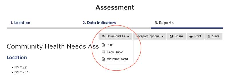
We recognize that many of our customers are currently working on assessments, improvement plans, etc – if you need to retain 2015-2019 ACS data in your reports, download them now! (Figure 1) If you are a Free/Intro/Pro subscriber, you can download as a PDF. Premium subscribers can also download Assessments in Word or Excel formats.
When the Assessments are updated in May 2022, the ACS indicators in the Assessment (including those in saved Assessments) will automatically update to the 2016-2020 data.
Check your Locations after the Release, Download Assessments
Census tract-based Locations: For those Premium customers who have created custom Locations using census tracts we recommend downloading any reports will need this month, as some of the existing census tracts will no longer exist due to merging and splitting, and regenerating your tract-based locations after the ACS release.
City/town-based Locations: For those customers who have created custom Locations using cities/towns, we recommend that you download your current reports (as described above), as those boundaries may change with the new ACS release. Additionally, check your locations after the update to make sure they still represent your communities of interest.
Custom/Draw My Area Locations: Same as above! Our small area estimation process relies on census tract information. As tracts may change with this release, data for a custom area may change also.
References
- https://www.census.gov/programs-surveys/acs
- https://www2.census.gov/geo/pdfs/education/CensusTracts.pdf
- https://www.census.gov/geographies/reference-maps/2020/geo/2020pl-maps.html
- https://www.census.gov/programs-surveys/acs/geography-acs/geography-boundaries-by-year.html
If you need any additional assistance please email us at sparkmap@missouri.edu